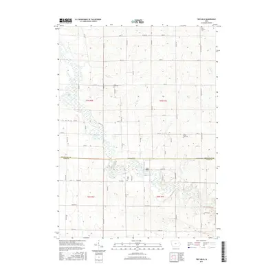
2015 Map of Troy Mills
USGS Topo · Published 2015About this map
Troy Mills occupies the center of this rural landscape, positioned at a notable bend where the local hydrology defines the settlement patterns. The boundary between Buchanan Co and Linn Co divides the northern agricultural plots from the southern reaches of the Cedar River watershed. This area is heavily marked by small local cemeteries that preserve the names of early settler families, such as Saint Patrick's Cem in the northeast and Circle Grove Cem farther west. The terrain is crisscrossed by a network of drainage systems including Honey Cr, W Otter Cr, and Dry Cr, which carve through the grid of gravel and paved roads. These waterways and the placement of Troy Mills Cem suggest a long-established community structure that remains anchored by the Wapsipinicon river valley despite the modernization of the surrounding road network like Co Rd W45.
Find a feature on this map
60 named features on this map. Tap any name to fly to it.
Don’t see what you’re looking for? This feature index may not catch every label — zoom into the map to look around manually.
Map Details
Editions of this 2015 Troy Mills Map
This is the sole edition of this map. No revisions or reprints were ever made.
Other maps of this area

1888 · Shellsburg
USGS Topo · 1:62,500

1888 · Marion
USGS Topo · 1:62,500

1889 · Marion
USGS Topo · 1:62,500

1889 · Shellsburg
USGS Topo · 1:62,500

1899 · Shellsburg
USGS Topo · 1:62,500

1903 · Winthrop
USGS Topo · 1:125,000

1959 · Dubuque
USGS Topo · 1:250,000

1961 · Dubuque
USGS Topo · 1:250,000

1962 · Dubuque
USGS Topo · 1:250,000
1968 · Central City
USGS Topo · 1:24,000