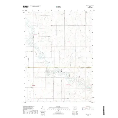
2018 Map of Troy Mills
USGS Topo · Published 2018About this map
Troy Mills occupies a prominent bend of the Wapsipinicon River, serving as a central point along the border of Buchanan and Linn counties. The surrounding landscape is defined by the winding river and its many tributaries, including Honey Cr and Sand Cr, which cut through a grid of rural roads like Walker Rd and Co Rd W45. Several early burial grounds are preserved across the townships, such as Saint Patrick's Cem and Upper Spring Grove Cem, providing valuable location data for genealogists tracing family histories in these rural reaches. The mapping shows a classic Iowa agricultural pattern, where family-named landmarks like Tucker Ave and Stewart Ave frame the farmsteads and wetlands that follow the river’s course.
Find a feature on this map
61 named features on this map. Tap any name to fly to it.
Don’t see what you’re looking for? This feature index may not catch every label — zoom into the map to look around manually.
Map Details
Editions of this 2018 Troy Mills Map
This is the sole edition of this map. No revisions or reprints were ever made.
Other maps of this area

1888 · Shellsburg
USGS Topo · 1:62,500

1888 · Marion
USGS Topo · 1:62,500

1889 · Marion
USGS Topo · 1:62,500

1889 · Shellsburg
USGS Topo · 1:62,500

1899 · Shellsburg
USGS Topo · 1:62,500

1903 · Winthrop
USGS Topo · 1:125,000

1959 · Dubuque
USGS Topo · 1:250,000

1961 · Dubuque
USGS Topo · 1:250,000

1962 · Dubuque
USGS Topo · 1:250,000
1968 · Central City
USGS Topo · 1:24,000