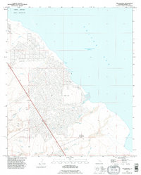
1992 Map of Truckhaven
USGS Topo · Published 1995About this map
Salton City dominates the western shoreline of the Salton Sea, showing an ambitious grid of residential streets carved into the desert landscape by the early 1990s. The map illustrates a community designed for growth, punctuated by multiple Mobile Home Park locations and a Golf Course along the arid flats. To the north, the Torres Martinez Indian Reservation occupies the shoreline, while the southern reaches contain the specialized Salton Sea Test Base B-1, reflecting the area's mix of recreation and government utility.
Find a feature on this map
26 named features on this map. Tap any name to fly to it.
Don’t see what you’re looking for? This feature index may not catch every label — zoom into the map to look around manually.
Map Details
Editions of this 1992 Truckhaven Map
This is the sole edition of this map. No revisions or reprints were ever made.
Other maps of this area

1904 · Indio
USGS Topo · 1:125,000

1931 · Vallecito
USGS Topo · 1:125,000

1940 · Kane Spring
USGS Topo · 1:62,500

1940 · Durmid
USGS Topo · 1:62,500

1942 · Barrel Spring
USGS Topo · 1:62,500

1942 · Agua Dulce
USGS Topo · 1:62,500

1943 · Vallecito
USGS Topo · 1:125,000

1944 · Agua Dulce
USGS Topo · 1:62,500

1944 · Durmid
USGS Topo · 1:62,500

1944 · Kane Spring
USGS Topo · 1:62,500