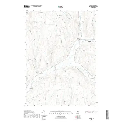
2019 Map of Truxton
USGS Topo · Published 2019About this map
The East Branch Tioughnioga River carves a deep valley through the high country of Cortland County, anchoring settlements like Truxton and East Homer along its banks. This 2019 survey captures a landscape where upland ridges such as Truxton Hill and Morgan Hill overlook a network of rural roads and farm-oriented hamlets. For the genealogist, the map identifies several burial sites including the Old Presbyterian Church Cem, Saint Patricks Cem, and the Truxton Rural Cem, providing precise locations for local family research. The valley floor is characterized by small communities like Crains Mills and East River, while numerous tributaries such as Kenney Brook, Albright Cr, and Cheningo Cr drain the surrounding hills. This modern record maintains the historical footprint of these Central New York settlements within their distinct topography.
Find a feature on this map
76 named features on this map. Tap any name to fly to it.
Don’t see what you’re looking for? This feature index may not catch every label — zoom into the map to look around manually.
Map Details
Editions of this 2019 Truxton Map
This is the sole edition of this map. No revisions or reprints were ever made.
Other maps of this area

1897 · Cazenovia
USGS Topo · 1:62,500

1899 · Cazenovia
USGS Topo · 1:62,500

1900 · Tully
USGS Topo · 1:62,500

1903 · Cortland
USGS Topo · 1:62,500

1904 · Pitcher
USGS Topo · 1:62,500

1943 · Otisco Valley
USGS Topo · 1:31,680
1943 · Tully
USGS Topo · 1:24,000

1943 · De Ruyter
USGS Topo · 1:24,000

1943 · Cincinnatus
USGS Topo · 1:24,000

1943 · Cuyler
USGS Topo · 1:24,000