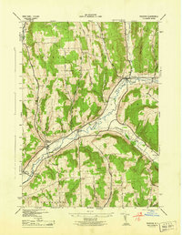
1944 Map of Truxton
USGS Topo · Published 1944About this map
The Tioughnioga River valley serves as the primary corridor for settlement and transit in this mid-century New York landscape. This survey captures a rural network of small hamlets and namesake mills, including Truxton and Crains Mills, linked by the Lehigh Valley railroad line. The map is particularly notable for its dense record of local education history, preserving the locations of numerous district schoolhouses such as the curiously named South America Sch, Log Sch, and Pelham Sch. The terrain is defined by significant elevations like Truxton Hill and Morgan Hill, which separate the river valley from the drainage of Cheningo Creek. These hillsides were home to a dispersed network of farms reached by early thoroughfares like South Hill Road and Gilbert Rd, providing a clear view of the agrarian economy before modern development consolidated these rural communities.
Find a feature on this map
38 named features on this map. Tap any name to fly to it.
Don’t see what you’re looking for? This feature index may not catch every label — zoom into the map to look around manually.
Map Details
Editions of this 1944 Truxton Map
This is the sole edition of this map. No revisions or reprints were ever made.
Other maps of this area

1897 · Cazenovia
USGS Topo · 1:62,500

1899 · Cazenovia
USGS Topo · 1:62,500

1900 · Tully
USGS Topo · 1:62,500

1903 · Cortland
USGS Topo · 1:62,500

1904 · Pitcher
USGS Topo · 1:62,500

1943 · Otisco Valley
USGS Topo · 1:31,680
1943 · Tully
USGS Topo · 1:24,000

1943 · De Ruyter
USGS Topo · 1:24,000

1943 · Cincinnatus
USGS Topo · 1:24,000

1943 · Cuyler
USGS Topo · 1:24,000