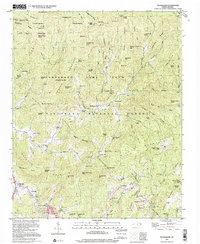
1997 Map of Tuckasegee
USGS Topo · Published 2001About this map
Tuckasegee and the upper reaches of the Tuckasegee River define this mountain landscape within the Nantahala National Forest. The map documents a scattered settlement pattern of small mountain communities and church centers like Argura, Cowarts, and Balsam Grove Ch. Educational and spiritual life in the late twentieth century is anchored by facilities such as Caney Fork Sch and Oak Hill Sch, alongside numerous family burial grounds including Shook Cem and Mathis Cem. Significant terrain features like Judaculla Rock and high points such as Sugarloaf Mtn and Wolfpen Gap reveal the orientation of traditional travel routes through the gaps. The presence of the Nantahala Game Land indicates the land's transition into protected wilderness, while the winding paths of Caney Fork and Sugar Creek illustrate the hydrologic network that supported these high-elevation homesteads and farms.
Find a feature on this map
89 named features on this map. Tap any name to fly to it.
Don’t see what you’re looking for? This feature index may not catch every label — zoom into the map to look around manually.
Map Details
Editions of this 1997 Tuckasegee Map
This is the sole edition of this map. No revisions or reprints were ever made.
Other maps of this area

1891 · Cowee
USGS Topo · 1:125,000

1897 · Cowee
USGS Topo · 1:125,000

1905 · Pisgah
USGS Topo · 1:125,000

1906 · Pisgah
USGS Topo · 1:125,000

1907 · Cowee
USGS Topo · 1:125,000

1935 · Waynesville
USGS Topo · 1:24,000

1935 · Sam Knob
USGS Topo · 1:24,000

1935 · Tuckaseigee
USGS Topo · 1:24,000

1935 · Hazelwood
USGS Topo · 1:24,000

1935 · Lake Toxaway
USGS Topo · 1:24,000