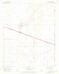
1968 Map of Tucker Mesa
USGS Topo · Published 1971About this map
Winslow Job Corps Civilian Conservation Center stands as a primary focal point in this high desert landscape along the border of Coconino and Navajo counties. The terrain is defined by broad plateaus and depressions, notably Tucker Mesa and Tucker Flat, as well as the prominent Toltec Divide. Human activity is concentrated along the critical transportation corridor of the Atchison Topeka and Santa Fe railroad, which bisects the quadrangle near Leupp Corner. The map captures a specialized infrastructure including a Radio Facility, Substation, and water management features like the Sewage Disposal Ponds and the aptly named Pruneville Well. Numerous Jeep Trails provide access across the arid landscape, connecting these remote installations and a local Gravel Pit to the primary highway routes.
Find a feature on this map
16 named features on this map. Tap any name to fly to it.
Don’t see what you’re looking for? This feature index may not catch every label — zoom into the map to look around manually.
Map Details
Editions of this 1968 Tucker Mesa Map
2 editions found
Other maps of this area

1883 · Tusayan
USGS Topo · 1:250,000

1886 · Tusayan
USGS Topo · 1:250,000

1886 · Holbrook
USGS Topo · 1:250,000

1893 · Holbrook
USGS Topo · 1:250,000

1947 · Flagstaff
USGS Topo · 1:250,000

1954 · Winslow
USGS Topo · 1:62,500

1954 · Winslow 4 NW
USGS Topo · 1:24,000

1954 · Winslow 4 SW
USGS Topo · 1:24,000

1954 · Flagstaff
USGS Topo · 1:250,000

1954 · Holbrook
USGS Topo · 1:250,000