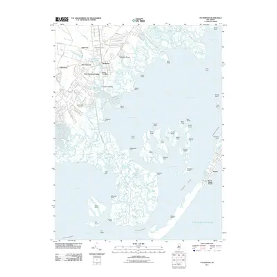
2011 Map of Tuckerton
USGS Topo · Published 2011About this map
Tuckerton and its neighboring settlements occupy the northern edge of this coastal landscape, where the terrestrial world gives way to the intricate wetlands of Little Egg Harbor. The transition from mainland to marsh is marked by a series of maritime landmarks including Scow Landing, West Tuckerton Landing, and Parkers Landing, which historically connected the local economy to the seafaring trade. Inland, the community of Nugentown and the grounds of Greenwood Cemetery suggest a long-standing local heritage, while more modern developments like Tuckerton Shores and the Ocean County Golf Course at Atlantis show the area's mid-to-late 20th-century residential expansion.
Find a feature on this map
104 named features on this map. Tap any name to fly to it.
Don’t see what you’re looking for? This feature index may not catch every label — zoom into the map to look around manually.
Map Details
Editions of this 2011 Tuckerton Map
This is the sole edition of this map. No revisions or reprints were ever made.
Other maps of this area

1887 · Atlantic City
USGS Topo · 1:62,500

1888 · Little Egg Harbor
USGS Topo · 1:62,500

1888 · Long Beach
USGS Topo · 1:62,500

1893 · Little Egg Harbor
USGS Topo · 1:62,500

1893 · Long Beach
USGS Topo · 1:62,500

1894 · Atlantic City
USGS Topo · 1:62,500

1919 · Long Beach
USGS Topo · 1:62,500

1920 · Little Egg Harbor
USGS Topo · 1:62,500

1940 · Atlantic City
USGS Topo · 1:62,500
1941 · Atlantic City
USGS Topo · 1:62,500
Featured Places
- Galloway Township, NJ
- Little Egg Harbor Township, NJ
- Tuckerton, NJ
- Long Beach Township, NJ
- Eagleswood Township, NJ