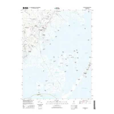
2016 Map of Tuckerton
USGS Topo · Published 2016About this map
Tuckerton and its surrounding coastal hamlets occupy a landscape defined by the intricate waterways of Little Egg Harbor and Tuckerton Bay. This 2016 survey highlights the maritime character of the Jersey Shore, where the mainland settlements of Parkertown and Giffordtown meet a labyrinth of tidal marshes. The map records the dense residential layout of Mystic Island and the thin, developed stretch of Long Beach Island, including Beach Haven and Holgate. Local history is visible in the placement of Greenwood Cem and several historic landings, such as Scow Landing and Parkers Landing, which suggest a long-standing reliance on the bay. Between the mainland and the barrier island, an expansive network of marsh islands including Story Island and Middle Island are separated by thoroughfares and channels like Big Sheepshead Creek, illustrating the complex estuarine environment of the Ocean and Atlantic County border.
Find a feature on this map
160 named features on this map. Tap any name to fly to it.
Don’t see what you’re looking for? This feature index may not catch every label — zoom into the map to look around manually.
Map Details
Editions of this 2016 Tuckerton Map
This is the sole edition of this map. No revisions or reprints were ever made.
Other maps of this area

1887 · Atlantic City
USGS Topo · 1:62,500

1888 · Little Egg Harbor
USGS Topo · 1:62,500

1888 · Long Beach
USGS Topo · 1:62,500

1893 · Little Egg Harbor
USGS Topo · 1:62,500

1893 · Long Beach
USGS Topo · 1:62,500

1894 · Atlantic City
USGS Topo · 1:62,500

1919 · Long Beach
USGS Topo · 1:62,500

1920 · Little Egg Harbor
USGS Topo · 1:62,500

1940 · Atlantic City
USGS Topo · 1:62,500
1941 · Atlantic City
USGS Topo · 1:62,500
Featured Places
- Galloway Township, NJ
- Little Egg Harbor Township, NJ
- Tuckerton, NJ
- Long Beach Township, NJ
- Eagleswood Township, NJ