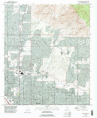
1992 Map of Tucson North
USGS Topo · Published 1995About this map
The northern reaches of Tucson meet the dramatic rise of the Santa Catalina Mountains in this early 1990s record. The landscape is defined by the sharp transition from the residential grids of Flowing Wells and Casas Adobes to the protected peaks of the Coronado National Forest. This era shows the suburban expansion pushing toward Oro Valley, while the Rillito River serves as a natural corridor through the developing desert floor.
Find a feature on this map
59 named features on this map. Tap any name to fly to it.
Don’t see what you’re looking for? This feature index may not catch every label — zoom into the map to look around manually.
Map Details
Editions of this 1992 Tucson North Map
This is the sole edition of this map. No revisions or reprints were ever made.
Other maps of this area

1904 · Tucson
USGS Topo · 1:125,000

1905 · Tucson
USGS Topo · 1:125,000

1925 · San Xavier
USGS Topo · 1:62,500

1934 · Tucson Mountains
USGS Topo · 1:125,000

1943 · San Xavier Mission
USGS Topo · 1:62,500

1947 · Cortaro
USGS Topo · 1:62,500

1948 · Tucson
USGS Topo · 1:62,500

1956 · Tucson
USGS Topo · 1:250,000

1957 · Tucson East
USGS Topo · 1:24,000

1957 · San Xavier Mission
USGS Topo · 1:62,500