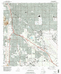
1992 Map of Tucson
USGS Topo · Published 1995About this map
The University of Arizona and the historic Old Pascua Yaqui Indian Village anchor the northern reaches of this metropolitan landscape, where the urban grid meets the course of the Santa Cruz River. This mid-1990s survey illustrates a city shaped by aviation and educational institutions, with the massive footprint of the Davis Monthan Air Force Base dominating the east and the Tucson International Airport at the southern edge. The residential and commercial density of Tucson and the enclave of South Tucson are bisected by major thoroughfares like Congress Street and the Aviation Highway. Notable landmarks such as Sentinel Peak Mountain provide a stark geographic contrast to the developed Santa Cruz Valley. Public spaces and leisure sites are well-documented, from the Reid Municipal Golf Course and Randolph Park to the local gathering grounds of Rodeo Park.
Find a feature on this map
33 named features on this map. Tap any name to fly to it.
Don’t see what you’re looking for? This feature index may not catch every label — zoom into the map to look around manually.
Map Details
Editions of this 1992 Tucson Map
This is the sole edition of this map. No revisions or reprints were ever made.
Other maps of this area

1904 · Tucson
USGS Topo · 1:125,000

1905 · Tucson
USGS Topo · 1:125,000

1925 · San Xavier
USGS Topo · 1:62,500

1934 · Tucson Mountains
USGS Topo · 1:125,000

1943 · San Xavier Mission
USGS Topo · 1:62,500

1947 · Cortaro
USGS Topo · 1:62,500

1948 · Tucson
USGS Topo · 1:62,500

1956 · Tucson
USGS Topo · 1:250,000

1957 · Tucson East
USGS Topo · 1:24,000

1957 · San Xavier Mission
USGS Topo · 1:62,500