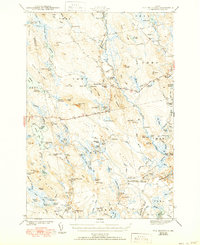
1943 Map of Tug Mountain
USGS Topo · Published 1950About this map
The Air Line Road cuts through this heavily forested landscape in Washington County, serving as the primary corridor for a region defined by its timber camps and interconnected waterways. The map records a series of specific family-named sites and logging outposts, including Hartford Camp, Allison Worcester Camp, and Irving Worcester Camp, reflecting the active wood-harvesting economy of the early 1940s. These remote settlements are positioned near water bodies such as Mopang Lake and the Machias River, where the terrain transitions from the low-lying Crebo Flat to prominent landmarks like Tug Mountain and Peaked Mtn.
Find a feature on this map
131 named features on this map. Tap any name to fly to it.
Don’t see what you’re looking for? This feature index may not catch every label — zoom into the map to look around manually.
Map Details
Editions of this 1943 Tug Mountain Map
2 editions found

Other maps of this area

1902 · Cherryfield
USGS Topo · 1:62,500

1904 · Cherryfield
USGS Topo · 1:62,500

1921 · Columbia Falls
USGS Topo · 1:62,500

1921 · Columbia Falls
USGS Topo · 1:62,500

1929 · Lead Mountain
USGS Topo · 1:48,000

1930 · Tunk Lake
USGS Topo · 1:48,000

1932 · Tunk Lake
USGS Topo · 1:62,500

1932 · Nicatous Lake
USGS Topo · 1:48,000

1932 · Lead Mountain
USGS Topo · 1:62,500

1934 · Nicatous Lake
USGS Topo · 1:62,500