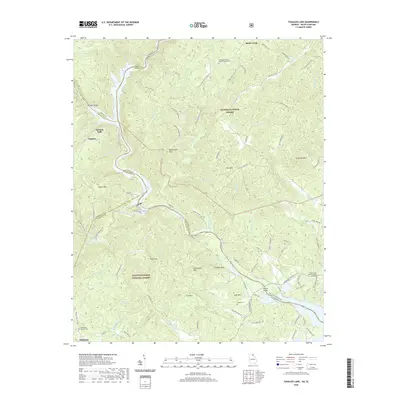
2020 Map of Tugaloo Lake
USGS Topo · Published 2020About this map
The Tugaloo River forms the winding state line between Georgia and South Carolina, carved into a landscape dominated by the Sumter National Forest and Chattahoochee National Forest. This 2020 map documents the complex topography of the Blue Ridge foothills, where the dramatic Tallulah Gorge and Tallulah Falls give way to the reservoirs of Tugaloo Lake and Yonah Lake. For genealogists and local historians, the sheet preserves several remote burial grounds, including the Damascus Baptist Church Graveyard and the Old Liberty Baptist Church Graveyard. The southern edge of the map reaches into the outskirts of Toccoa, while the interior is marked by named summits such as Boatwright Mtn and Yellowback Mtn. Settlement remains sparse throughout this protected corridor, primarily limited to small clusters along routes like Cooper Rd and near the Prather Bridge crossing.
Find a feature on this map
112 named features on this map. Tap any name to fly to it.
Don’t see what you’re looking for? This feature index may not catch every label — zoom into the map to look around manually.
Map Details
Editions of this 2020 Tugaloo Lake Map
This is the sole edition of this map. No revisions or reprints were ever made.
Other maps of this area

1886 · Walhalla
USGS Topo · 1:125,000

1892 · Walhalla
USGS Topo · 1:125,000

1896 · Walhalla
USGS Topo · 1:125,000

1953 · Tallulah Falls
USGS Topo · 1:24,000

1954 · Greenville
USGS Topo · 1:250,000
1957 · Tiger
USGS Topo · 1:24,000

1957 · Tugaloo Lake
USGS Topo · 1:24,000
1957 · Rainy Mountain
USGS Topo · 1:24,000

1958 · Greenville
USGS Topo · 1:250,000
1961 · Whetstone
USGS Topo · 1:24,000