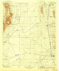
1916 Map of Tularosa
USGS Topo · Published 1943About this map
White Sands and the vast Alkali Flat dominate this early twentieth-century landscape in the Tularosa Basin. The survey highlights a rugged transition between the San Andres Mountains to the west, featuring Capitol Peak and the Mockingbird Gap Mine, and the Phillips Hills and Godfrey Hills to the east. The arid terrain is defined by its water sources, from the Tularosa River sustaining the settlement of Tularosa to scattered vital points like Malpais Spring and Mound Springs.
Find a feature on this map
47 named features on this map. Tap any name to fly to it.
Don’t see what you’re looking for? This feature index may not catch every label — zoom into the map to look around manually.
Map Details
Editions of this 1916 Tularosa Map
2 editions found
Other maps of this area

1916 · Tonuco
USGS Topo · 1:125,000

1916 · Salinas Peak
USGS Topo · 1:125,000

1916 · Tularosa
USGS Topo · 1:125,000

1916 · Point Of Sands
USGS Topo · 1:125,000

1918 · Oscura Peak
USGS Topo · 1:125,000

1932 · Tonuco
USGS Topo · 1:125,000

1938 · Carrizozo
USGS Topo · 1:48,000

1943 · Carrizozo
USGS Topo · 1:62,500

1947 · Point Of Sands 2
USGS Topo · 1:62,500

1947 · Three Rivers
USGS Topo · 1:62,500