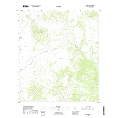
2019 Map of Tule Mountain
USGS Topo · Published 2019About this map
Big Bend National Park dominates this desert landscape, characterized by isolated peaks and seasonal drainage systems. The terrain is anchored by the prominent Tule Mtn in the south and the Chisos Mountains rising to the east, with Burro Mesa providing a distinct elevated plateau between them. Water sources, vital in this arid environment, are marked by locations like Bitter Spring, Indian Head Spring, and Gano Springs, which likely served as critical landmarks for early travelers and inhabitants. Transport through this portion of the Trans-Pecos is defined by the Panther Junction Rd and the Ross Maxwell Scenic Dr, routes that trace the natural contours of the land. Landmarks such as The Sphinx and Maverick Mtn stand as notable navigational points, while deep incisions like Apache Canyon and various arroyos including Rough Run and Alamo Cr illustrate the region's complex drainage patterns.
Find a feature on this map
23 named features on this map. Tap any name to fly to it.
Don’t see what you’re looking for? This feature index may not catch every label — zoom into the map to look around manually.
Map Details
Editions of this 2019 Tule Mountain Map
This is the sole edition of this map. No revisions or reprints were ever made.
Other maps of this area

1903 · Chisos Mountains
USGS Topo · 1:125,000

1903 · Terlingua
USGS Topo · 1:125,000

1904 · Terlingua
USGS Topo · 1:125,000

1905 · Chisos Mountains
USGS Topo · 1:125,000

1959 · Emory Peak
USGS Topo · 1:250,000

1965 · Emory Peak
USGS Topo · 1:250,000

1971 · Terlingua
USGS Topo · 1:24,000

1971 · Cerro Castellan
USGS Topo · 1:24,000
1971 · Christmas Mountians
USGS Topo · 1:24,000
1971 · Hen Egg Mountain
USGS Topo · 1:24,000