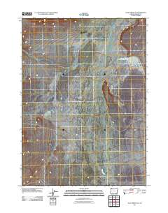
2011 Map of Tule Springs NE
USGS Topo · Published 2011About this map
Willow Creek flows through this high desert terrain in the southeastern corner of Harney County, illustrating the sparse but critical water network of the Oregon outback. The landscape is defined by its drainage patterns, with the most significant landmark being the Upper Willow Creek Waterhole, a vital resource for livestock and wildlife in this arid region. This 2011 edition shows the intersection of intermittent stream beds and the fundamental topography that has dictated land use for generations. The lack of named settlements reflects the vast open space and grazing economy typical of this part of the state.
Find a feature on this map
2 named features on this map. Tap any name to fly to it.
Don’t see what you’re looking for? This feature index may not catch every label — zoom into the map to look around manually.
Map Details
Editions of this 2011 Tule Springs NE Map
This is the sole edition of this map. No revisions or reprints were ever made.
Other maps of this area

1955 · Adel
USGS Topo · 1:250,000

1957 · Adel
USGS Topo · 1:250,000

1958 · Adel
USGS Topo · 1:250,000

1962 · Adel
USGS Topo · 1:250,000

1981 · Coyote Lake West
USGS Topo · 1:24,000

1981 · Tule Springs
USGS Topo · 1:24,000

1981 · Tule Springs NE
USGS Topo · 1:24,000

1981 · Miranda Flat SW
USGS Topo · 1:24,000

1981 · Miranda Flat SE
USGS Topo · 1:24,000
1981 · Red Mountain
USGS Topo · 1:24,000