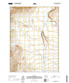
2020 Map of Tule Springs NE
USGS Topo · Published 2020About this map
Willow Cr defines the primary drainage of this landscape in Harney County, flowing southward through a series of intermittent wetlands. The terrain is structured by the Public Land Survey System, with the boundaries of t35s r35e, t35s r36e, t36s r35e, and t36s r36e intersecting near the center of the sheet. This area reflects the characteristic high desert topography of eastern Oregon, where subtle elevation changes and seasonal watercourses dictate the pattern of the land. The mapping illustrates a sparse and open environment, largely devoid of modern development or permanent settlements, preserving the foundational survey grid that has organized this portion of the state for over a century.
Find a feature on this map
5 named features on this map. Tap any name to fly to it.
Don’t see what you’re looking for? This feature index may not catch every label — zoom into the map to look around manually.
Map Details
Editions of this 2020 Tule Springs NE Map
This is the sole edition of this map. No revisions or reprints were ever made.
Other maps of this area

1955 · Adel
USGS Topo · 1:250,000

1957 · Adel
USGS Topo · 1:250,000

1958 · Adel
USGS Topo · 1:250,000

1962 · Adel
USGS Topo · 1:250,000

1981 · Coyote Lake West
USGS Topo · 1:24,000

1981 · Tule Springs
USGS Topo · 1:24,000

1981 · Tule Springs NE
USGS Topo · 1:24,000

1981 · Miranda Flat SW
USGS Topo · 1:24,000

1981 · Miranda Flat SE
USGS Topo · 1:24,000
1981 · Red Mountain
USGS Topo · 1:24,000