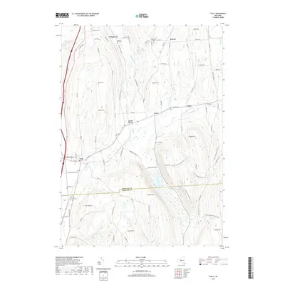
2019 Map of Tully
USGS Topo · Published 2019About this map
Tully and Apulia Station sit at the center of this 2019 survey, illustrating the persistence of small settlements along the border of Onondaga and Cortland counties. The landscape is defined by significant relief, featuring high points such as The Pinnacle and Jones Hill that overlook the valley floor. Waterways like Butternut Cr and Labrador Creek drain the area, with the latter leading toward the dramatic drop at Tinker Falls. The map reveals a high concentration of burial grounds, including the Old Tully Cem and Maplewood Rural Cem, which are invaluable for genealogists tracing early families in the region. Transportation and recreation are represented by the rural road network and the N Country National Scenic Trail, which winds across the rugged eastern slopes of Labrador Hill and Morgan Hill.
Find a feature on this map
85 named features on this map. Tap any name to fly to it.
Don’t see what you’re looking for? This feature index may not catch every label — zoom into the map to look around manually.
Map Details
Editions of this 2019 Tully Map
This is the sole edition of this map. No revisions or reprints were ever made.
Other maps of this area

1897 · Cazenovia
USGS Topo · 1:62,500

1899 · Cazenovia
USGS Topo · 1:62,500

1900 · Tully
USGS Topo · 1:62,500

1903 · Cortland
USGS Topo · 1:62,500

1904 · Pitcher
USGS Topo · 1:62,500

1942 · Oran
USGS Topo · 1:24,000

1943 · South Onondaga
USGS Topo · 1:31,680

1943 · Jamesville
USGS Topo · 1:31,680

1943 · Otisco Valley
USGS Topo · 1:31,680
1943 · Oran
USGS Topo · 1:31,680