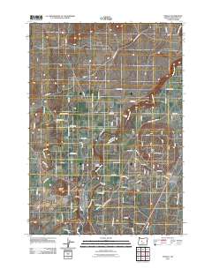
2011 Map of Tumalo
USGS Topo · Published 2011About this map
The Deschutes River carves through this Central Oregon landscape, anchoring a rural network of roads and irrigation works north of Bend. At the heart of the region, the settlement of Tumalo sits near the river's edge, while the high ground of Laidlaw Butte and Long Butte provides clear geographical markers. This 2011 survey reveals how early agricultural infrastructure, such as the Swalley Canal, continues to shape land use alongside modern developments like the Old Bend Redmond Hwy. Local historians will find specific value in the location of the Tumalo Cemetery and the convergence of transport lines at Deschutes Junction. The map details a transition from the river's path, marked by features like Aubrey Falls, to the structured grid of rural lanes including Innes Market Rd and Cline Falls Rd.
Find a feature on this map
85 named features on this map. Tap any name to fly to it.
Don’t see what you’re looking for? This feature index may not catch every label — zoom into the map to look around manually.
Map Details
Editions of this 2011 Tumalo Map
This is the sole edition of this map. No revisions or reprints were ever made.
Other maps of this area

1926 · Bend
USGS Topo · 1:125,000

1929 · Bend
USGS Topo · 1:125,000

1955 · Bend
USGS Topo · 1:250,000

1957 · Bend
USGS Topo · 1:250,000

1958 · Bend
USGS Topo · 1:250,000

1961 · Redmond
USGS Topo · 1:24,000

1962 · Forked Horn Butte
USGS Topo · 1:24,000
1962 · Bend
USGS Topo · 1:24,000
1962 · Bend Airport
USGS Topo · 1:24,000
1962 · Redmond
USGS Topo · 1:24,000