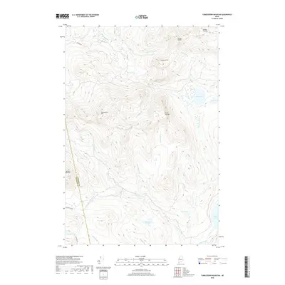
2018 Map of Tumbledown Mountain
USGS Topo · Published 2018About this map
Tumbledown Mountain and its surrounding peaks dominate this interior Maine landscape along the border of Franklin and Somerset counties. The area is defined by a dense network of watercourses, including Spencer Stream and Baker Stream, which drain numerous high-elevation basins such as Blakeslee Lake and Rock Pond. At the time of this 2018 survey, the terrain remains largely accessed by unpaved corridors like Appleton Rd and Spencer Bale Rd, reflecting the timber-and-stream geography of the region. Distinctive landmarks such as Three Slide Mountain and Spencer Bale Mountain provide clear points of orientation for those studying the drainage patterns of Gold Brook and Spaulding Brook. The map reveals a land focused on its natural topography and hydrology, with few permanent structures but numerous named summits and remote ponds.
Find a feature on this map
32 named features on this map. Tap any name to fly to it.
Don’t see what you’re looking for? This feature index may not catch every label — zoom into the map to look around manually.
Map Details
Editions of this 2018 Tumbledown Mountain Map
This is the sole edition of this map. No revisions or reprints were ever made.
Other maps of this area

1923 · Attean
USGS Topo · 1:62,500

1925 · Attean
USGS Topo · 1:62,500

1928 · Chain Lakes
USGS Topo · 1:48,000

1928 · Skinner
USGS Topo · 1:48,000

1928 · Spencer
USGS Topo · 1:48,000

1931 · Skinner
USGS Topo · 1:62,500

1932 · Spencer
USGS Topo · 1:62,500

1932 · Chain Lakes
USGS Topo · 1:62,500

1935 · Chain Lakes
USGS Topo · 1:62,500

1949 · Jackman
USGS Topo · 1:250,000
Featured Places
- Rayton Township, ME
- Skinner Township, ME
- Haynestown Township, ME
- King & Bartlett Township, ME
- Kibby Township, ME