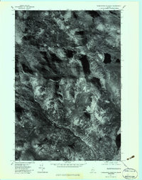
1977 Map of Tumbledown Mountain
USGS Topo · Published 1983About this map
Tumbledown Mountain and Three Slide Mountain define this orthophotoquad, which captures the Somerset County backcountry through high-altitude aerial imagery from late 1977. Unlike traditional topographic maps, this edition uses rectified photography to show the actual texture of the forest cover and the drainage patterns of the upper Kennebec basin. The map reveals the intricate water network of the Maine woods, including Rock Pond and Baker Pond. This specific format was designed for land management and forestry, providing a visual record of the region's timbered slopes and the winding courses of Spencer Stream, Baker Stream, and the West Branch. The contrast in the imagery helps distinguish between the dense canopy of the ridges and the low-lying wetlands around Bog Brook.
Find a feature on this map
8 named features on this map. Tap any name to fly to it.
Don’t see what you’re looking for? This feature index may not catch every label — zoom into the map to look around manually.
Map Details
Editions of this 1977 Tumbledown Mountain Map
This is the sole edition of this map. No revisions or reprints were ever made.
Other maps of this area

1923 · Attean
USGS Topo · 1:62,500

1925 · Attean
USGS Topo · 1:62,500

1928 · Chain Lakes
USGS Topo · 1:48,000

1928 · Skinner
USGS Topo · 1:48,000

1928 · Spencer
USGS Topo · 1:48,000

1931 · Skinner
USGS Topo · 1:62,500

1932 · Spencer
USGS Topo · 1:62,500

1932 · Chain Lakes
USGS Topo · 1:62,500

1935 · Chain Lakes
USGS Topo · 1:62,500

1949 · Jackman
USGS Topo · 1:250,000
Featured Places
- Haynestown Township, ME
- Kibby Township, ME
- Rayton Township, ME
- Skinner Township, ME
- Appleton Township, ME