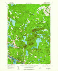
1957 Map of Tunk Lake
USGS Topo · Published 1963About this map
The coastal inlets and granite peaks of eastern Maine are documented here in the mid-1950s, centered on the complex water systems of Tunk Lake and Donnell Pond. The southern edge of the map shows the tidal activity of Sullivan Harbor and Hog Bay, where settlements like Sullivan and Waukeag are connected by the Maine Central railroad. Moving inland, the landscape rises sharply into the summits of Tunk Mountain and Schoodic Mtn, the latter featuring a Lookout Tower overlooking the surrounding glacial lakes. The settlement patterns reflect a mix of small-town infrastructure and seasonal recreation, evidenced by Buckskin Camp and Big Chief Camps near the water, while the Deblois Airport and a Fish Hatchery near the Narraguagus River show the local economy's intersection with aviation and conservation. Several Quarries near North Sullivan indicate the area's granite industry, a hallmark of this coastal region.
Find a feature on this map
136 named features on this map. Tap any name to fly to it.
Don’t see what you’re looking for? This feature index may not catch every label — zoom into the map to look around manually.
Map Details
Editions of this 1957 Tunk Lake Map
4 editions found
Other maps of this area

1902 · Cherryfield
USGS Topo · 1:62,500

1904 · Cherryfield
USGS Topo · 1:62,500

1904 · Mount Desert
USGS Topo · 1:62,500

1904 · Bar Harbor
USGS Topo · 1:62,500

1904 · Petit Manan
USGS Topo · 1:62,500

1911 · Ellsworth
USGS Topo · 1:62,500

1929 · Great Pond
USGS Topo · 1:48,000

1929 · Lead Mountain
USGS Topo · 1:48,000

1930 · Tunk Lake
USGS Topo · 1:48,000

1932 · Tunk Lake
USGS Topo · 1:62,500