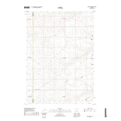
2017 Map of Turk Springs
USGS Topo · Published 2017About this map
The S Fork Red Fork Powder River defines the northern reaches of this high-elevation terrain along the boundary of Washakie Co and Johnson Co. This landscape is characterized by a series of prominent high ridges, including Telephone Ridge, Road Ridge, and the ominously named Poison Weed Ridge, which underscore the region's history of cattle grazing and open-range navigation. Evidence of land use for livestock is further seen in the naming of Bachaus Pasture and the access provided by Bachus Pasture Rd.
Find a feature on this map
24 named features on this map. Tap any name to fly to it.
Don’t see what you’re looking for? This feature index may not catch every label — zoom into the map to look around manually.
Map Details
Editions of this 2017 Turk Springs Map
This is the sole edition of this map. No revisions or reprints were ever made.
Other maps of this area

1955 · Arminto
USGS Topo · 1:250,000

1958 · Arminto
USGS Topo · 1:250,000

1961 · Barnum
USGS Topo · 1:62,500

1962 · Arminto
USGS Topo · 1:250,000

1963 · Mayoworth
USGS Topo · 1:62,500
1966 · Tallon Spring
USGS Topo · 1:24,000
1967 · Tabletop
USGS Topo · 1:24,000

1967 · Horse Butte
USGS Topo · 1:24,000

1967 · Gordon Creek
USGS Topo · 1:24,000

1967 · Turk Springs
USGS Topo · 1:24,000