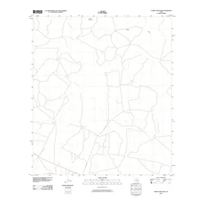
2010 Map of Turkey Mountain
USGS Topo · Published 2010About this map
Turkey Mountain rises as a central landmark in this Southwest Texas landscape, marking the high ground between several major drainage systems. The map details a complex network of seasonal watercourses, including the Arenosa Creek flowing through the west and the dual branches of West Fork Turkey Creek and East Fork Turkey Creek to the east. Sparse human infrastructure is represented by rural thoroughfares like Schubach Ln and Bustin Ln, which navigate the terrain of Rough Hollow and the flats near East Fork Elm Creek. This survey captures the ranching character of Kinney County at the beginning of the 21st century, illustrating how property boundaries and local roads have adapted to the natural contours of the brush country.
Find a feature on this map
8 named features on this map. Tap any name to fly to it.
Don’t see what you’re looking for? This feature index may not catch every label — zoom into the map to look around manually.
Map Details
Editions of this 2010 Turkey Mountain Map
This is the sole edition of this map. No revisions or reprints were ever made.
Other maps of this area

1896 · Brackett
USGS Topo · 1:125,000

1897 · Brackett
USGS Topo · 1:125,000

1938 · Turkey Mountain
USGS Topo · 1:48,000

1943 · Turkey Mountain
USGS Topo · 1:62,500

1944 · Spofford
USGS Topo · 1:62,500

1944 · Brackettville
USGS Topo · 1:62,500

1949 · Cline
USGS Topo · 1:62,500

1958 · Del Rio
USGS Topo · 1:250,000

1964 · Del Rio
USGS Topo · 1:250,000
1974 · Elm Mountain
USGS Topo · 1:24,000