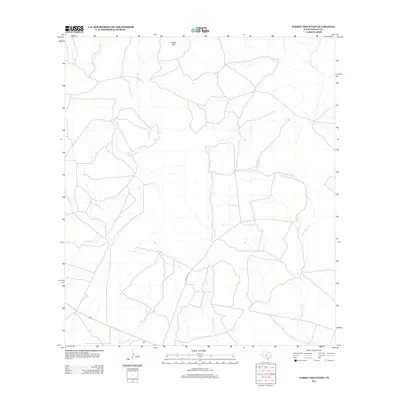
2012 Map of Turkey Mountain
USGS Topo · Published 2012About this map
Turkey Mtn rises above the drainage networks of eastern Kinney County, where the landscape is defined by the headwaters of several significant regional waterways. The southern portion of this region is marked by the path of Schubach Ln, providing access to the sparse ranching and hunting lands that characterize this part of the Texas Hill Country. The map reveals an intricate system of ephemeral streams, including the winding Arenosa Cr and the diverging branches of W Fork Turkey Cr and E Fork Turkey Cr. Further south, the E Fork Elm Cr cuts through the territory, illustrating the complex water-table geography that dictates settlement and land use in this arid environment. The pattern of roads and watercourses suggests a remote, rural landscape centered on large-scale landholdings and natural landmarks.
Find a feature on this map
6 named features on this map. Tap any name to fly to it.
Don’t see what you’re looking for? This feature index may not catch every label — zoom into the map to look around manually.
Map Details
Editions of this 2012 Turkey Mountain Map
This is the sole edition of this map. No revisions or reprints were ever made.
Other maps of this area

1896 · Brackett
USGS Topo · 1:125,000

1897 · Brackett
USGS Topo · 1:125,000

1938 · Turkey Mountain
USGS Topo · 1:48,000

1943 · Turkey Mountain
USGS Topo · 1:62,500

1944 · Spofford
USGS Topo · 1:62,500

1944 · Brackettville
USGS Topo · 1:62,500

1949 · Cline
USGS Topo · 1:62,500

1958 · Del Rio
USGS Topo · 1:250,000

1964 · Del Rio
USGS Topo · 1:250,000
1974 · Elm Mountain
USGS Topo · 1:24,000