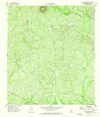
1974 Map of Turkey Mountain
USGS Topo · Published 1976About this map
Turkey Mountain rises as the central landmark of this landscape in Kinney County, Texas, serving as a high point amidst a network of seasonal watercourses. The 1974 field-checked topography shows a terrain defined by drainage patterns, where the West Fork Turkey Creek and East Fork Turkey Creek converge in the southern portion of the quadrangle. These drainages, along with the Arenosa Creek to the west and the East Fork Elm Creek in the southwest, illustrate the intricate hydrologic character of the Edwards Plateau region. Evidence of local industry and access is visible through the presence of a Gravel Pit near the southern boundary and various Jeep Trails and Wells scattered across the cattle-country landscape, reflecting the land use of the mid-1970s.
Find a feature on this map
9 named features on this map. Tap any name to fly to it.
Don’t see what you’re looking for? This feature index may not catch every label — zoom into the map to look around manually.
Map Details
Editions of this 1974 Turkey Mountain Map
This is the sole edition of this map. No revisions or reprints were ever made.
Other maps of this area

1896 · Brackett
USGS Topo · 1:125,000

1897 · Brackett
USGS Topo · 1:125,000

1938 · Turkey Mountain
USGS Topo · 1:48,000

1943 · Turkey Mountain
USGS Topo · 1:62,500

1944 · Spofford
USGS Topo · 1:62,500

1944 · Brackettville
USGS Topo · 1:62,500

1949 · Cline
USGS Topo · 1:62,500

1958 · Del Rio
USGS Topo · 1:250,000

1964 · Del Rio
USGS Topo · 1:250,000
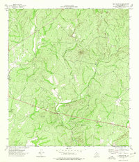
1974 · Elm Mountain
USGS Topo · 1:24,000