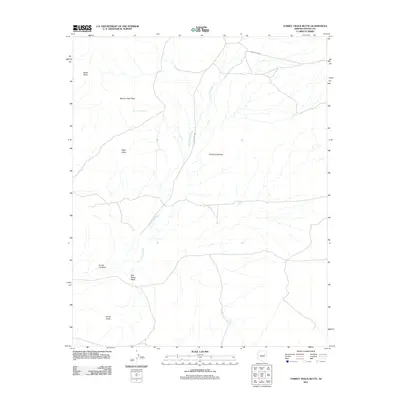
2011 Map of Turkey Track Butte
USGS Topo · Published 2011About this map
Turkey Track Butte dominates this Navajo County landscape, where the high desert terrain is defined by a series of prominent volcanic or erosional landforms and seasonal drainages. The area is characterized by scattered water sources vital to this arid environment, such as Mexican Rest Spring located near Mexican Rest Peak. A network of unpaved routes, including Indian Rte-9860 and Indian Rte-9861, provides access through the expansive drainage systems of Cottonwood Wash and Salt Seeps Wash. These washes dictate the local topography, carving paths between named landmarks like Sharp Butte, Edge Butte, and the interestingly titled Coyote Joe Rock. The map illustrates a largely open territory, likely utilized for seasonal grazing or transit, where the naming of specific peaks and springs serves as critical navigational markers in a sparsely populated region of the Fort Defiance Agency.
Find a feature on this map
11 named features on this map. Tap any name to fly to it.
Don’t see what you’re looking for? This feature index may not catch every label — zoom into the map to look around manually.
Map Details
Editions of this 2011 Turkey Track Butte Map
This is the sole edition of this map. No revisions or reprints were ever made.
Other maps of this area

1883 · Tusayan
USGS Topo · 1:250,000

1886 · Tusayan
USGS Topo · 1:250,000

1947 · Flagstaff
USGS Topo · 1:250,000

1954 · Flagstaff
USGS Topo · 1:250,000

1958 · Flagstaff
USGS Topo · 1:250,000

1960 · Flagstaff
USGS Topo · 1:250,000

1962 · Flagstaff
USGS Topo · 1:250,000
1967 · French Butte
USGS Topo · 1:24,000
1972 · Turkey Track Butte
USGS Topo · 1:24,000
1972 · Mitten Peak
USGS Topo · 1:24,000