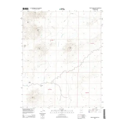
2014 Map of Turkey Track Butte
USGS Topo · Published 2014About this map
Turkey Track Butte serves as a central landmark in this high-desert landscape, where the drainage patterns of Cottonwood Wash and Salt Seeps Wash define the local topography. This 2014 survey reveals an area largely shaped by isolated geological formations and seasonal water sources rather than dense settlement. Notable summits like Mexican Rest Peak, Sharp Butte, and Edge Butte punctuate the horizon, while smaller features such as Mexican Rest Spring indicate the critical importance of water in this arid region.
Find a feature on this map
18 named features on this map. Tap any name to fly to it.
Don’t see what you’re looking for? This feature index may not catch every label — zoom into the map to look around manually.
Map Details
Editions of this 2014 Turkey Track Butte Map
This is the sole edition of this map. No revisions or reprints were ever made.
Other maps of this area

1883 · Tusayan
USGS Topo · 1:250,000

1886 · Tusayan
USGS Topo · 1:250,000

1947 · Flagstaff
USGS Topo · 1:250,000

1954 · Flagstaff
USGS Topo · 1:250,000

1958 · Flagstaff
USGS Topo · 1:250,000

1960 · Flagstaff
USGS Topo · 1:250,000

1962 · Flagstaff
USGS Topo · 1:250,000
1967 · French Butte
USGS Topo · 1:24,000
1972 · Turkey Track Butte
USGS Topo · 1:24,000
1972 · Mitten Peak
USGS Topo · 1:24,000