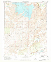
1968 Map of Turlock Lake
USGS Topo · Published 1971About this map
Turlock Lake dominates the northern landscape of this survey, surrounded by the recreational grounds of Turlock Lake State Park. The region's agricultural character is defined by an extensive irrigation network, including the Main Canal and North Side Canal, which divert water across the undulating terrain. To the south, the natural drainage of Dry Creek and Peaslee Creek winds toward the Ingalsbe Slough, illustrating the transition from managed water systems to the area's original riparian features. The map captures the boundary line between Stanislaus County and Merced County, with a grid of rural routes such as Silva Road and Keyes Road providing access to the various wells and agricultural plots that sustain the local economy during this era.
Find a feature on this map
19 named features on this map. Tap any name to fly to it.
Don’t see what you’re looking for? This feature index may not catch every label — zoom into the map to look around manually.
Map Details
Editions of this 1968 Turlock Lake Map
2 editions found
Other maps of this area

1893 · Sonora
USGS Topo · 1:125,000

1896 · Sonora
USGS Topo · 1:125,000

1897 · Sonora
USGS Topo · 1:125,000

1898 · Sonora
USGS Topo · 1:125,000

1913 · Dickenson
USGS Topo · 1:31,680

1915 · Paulsell
USGS Topo · 1:31,680

1915 · La Grange
USGS Topo · 1:24,000

1916 · Three Tree Flat
USGS Topo · 1:31,680

1916 · Hopeton
USGS Topo · 1:31,680

1916 · Cressey
USGS Topo · 1:31,680