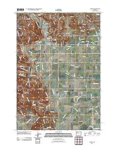
2011 Map of Turner
USGS Topo · Published 2011About this map
Turner and the surrounding Willamette Valley landscape are defined by an intricate network of waterways and early burial grounds. The community is situated along Mill Creek, which flows near the Turner Post Office and Franzen Reservoir. The area is notably dense with historical resting places, from the Independent Order of Odd Fellows Cemetery to the Penitentiary Annex Cemetery and Shaw Catholic Cemetery.
Find a feature on this map
110 named features on this map. Tap any name to fly to it.
Don’t see what you’re looking for? This feature index may not catch every label — zoom into the map to look around manually.
Map Details
Editions of this 2011 Turner Map
This is the sole edition of this map. No revisions or reprints were ever made.
Other maps of this area

1912 · Jefferson
USGS Topo · 1:31,680

1915 · Eola
USGS Topo · 1:31,680

1915 · Sidney
USGS Topo · 1:31,680

1916 · Albany
USGS Topo · 1:62,500

1917 · Salem
USGS Topo · 1:62,500

1921 · Lebanon
USGS Topo · 1:62,500

1922 · Lebanon
USGS Topo · 1:48,000

1924 · Lebanon
USGS Topo · 1:62,500

1925 · Stayton
USGS Topo · 1:62,500

1940 · Lebanon
USGS Topo · 1:62,500