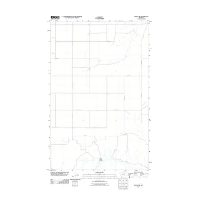
2011 Map of Turner SE
USGS Topo · Published 2011About this map
Little Jewel Coulee meanders through the southern portion of this landscape, carving into the high plains of Blaine County. This 2011 survey illustrates the rural infrastructure of the Big Flat region, where a geometric grid of section-line roads facilitates agriculture and ranching. Family-named routes such as Wolery Rd, Tooke Rd, and Cederberg Rd define the local geography, serving as a record of early 21st-century property access and settlement patterns in this northern Montana prairie. Notable through-routes include Loring Rd and Cornell Rd, which connect remote homesteads across the drainage divides between Black Coulee Rd and the coulees to the south. The mapping of Little Jewell Rd and Scones Ln provides researchers with a precise view of the local transport network as it functioned before more recent landscape shifts.
Find a feature on this map
11 named features on this map. Tap any name to fly to it.
Don’t see what you’re looking for? This feature index may not catch every label — zoom into the map to look around manually.
Map Details
Editions of this 2011 Turner SE Map
This is the sole edition of this map. No revisions or reprints were ever made.
Other maps of this area

1920 · Avery
USGS Topo · 1:125,000

1953 · Havre
USGS Topo · 1:250,000

1957 · Havre
USGS Topo · 1:250,000

1958 · Havre
USGS Topo · 1:250,000

1984 · Chapman
USGS Topo · 1:24,000

1984 · Emerick Bench
USGS Topo · 1:24,000
1984 · Chapman NW
USGS Topo · 1:24,000

1984 · Turner
USGS Topo · 1:24,000

1984 · Turner NE
USGS Topo · 1:24,000
1984 · Down Reservoir NW
USGS Topo · 1:24,000