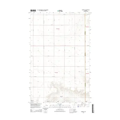
2014 Map of Turner SE
USGS Topo · Published 2014About this map
The rolling plains of the High Line near the Blaine Co Phillips Co boundary are defined by a grid of rural roads and drainage channels. This 2014 survey documents the agricultural landscape south of the Canadian border, where the land is carved by the winding paths of Little Jewel Coulee and Black Coulee. The rectilinear road network, including Country Club Rd, Tooke Rd, and Yellow Rd, illustrates the systematic division of the Public Land Survey System across the northern Montana prairie. These routes provide access to the vast tracts of land categorized under townships such as t36n r26e and t35n r26e. The geography here is sparse, characterized by significant elevation changes near the coulees contrasted against the high, flat plateaus where local landmarks like Cornell Rd and Skones Ln trace the section lines of the ranching country.
Find a feature on this map
25 named features on this map. Tap any name to fly to it.
Don’t see what you’re looking for? This feature index may not catch every label — zoom into the map to look around manually.
Map Details
Editions of this 2014 Turner SE Map
This is the sole edition of this map. No revisions or reprints were ever made.
Other maps of this area

1920 · Avery
USGS Topo · 1:125,000

1953 · Havre
USGS Topo · 1:250,000

1957 · Havre
USGS Topo · 1:250,000

1958 · Havre
USGS Topo · 1:250,000

1984 · Chapman
USGS Topo · 1:24,000

1984 · Emerick Bench
USGS Topo · 1:24,000
1984 · Chapman NW
USGS Topo · 1:24,000

1984 · Turner
USGS Topo · 1:24,000

1984 · Turner NE
USGS Topo · 1:24,000
1984 · Down Reservoir NW
USGS Topo · 1:24,000