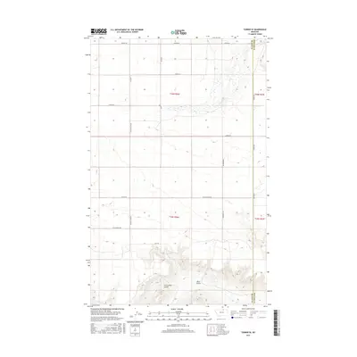
2017 Map of Turner SE
USGS Topo · Published 2017About this map
Black Coulee and Little Jewel Coulee carve through this high plains landscape along the county line in north-central Montana. The map illustrates a sparse, grid-based network of rural routes that facilitate the ranching and agricultural operations of the region. Notable local thoroughfares include Wolery Rd and Loring Rd, which intersect with north-south connections like Tooke Rd and Country Club Rd. The boundary between Blaine Co and Phillips Co runs vertically through the eastern portion of the survey, where Corneu Rd traces the border. Significant elevation changes are concentrated in the southern sections, where the terrain drops toward the drainage systems. This 2017 survey by the U.S. Geological Survey provides a precise view of the modern land divisions and access roads such as Little Jewell Rd and Cederberg Rd that define this remote section of the Big Sky Country.
Find a feature on this map
18 named features on this map. Tap any name to fly to it.
Don’t see what you’re looking for? This feature index may not catch every label — zoom into the map to look around manually.
Map Details
Editions of this 2017 Turner SE Map
This is the sole edition of this map. No revisions or reprints were ever made.
Other maps of this area

1920 · Avery
USGS Topo · 1:125,000

1953 · Havre
USGS Topo · 1:250,000

1957 · Havre
USGS Topo · 1:250,000

1958 · Havre
USGS Topo · 1:250,000

1984 · Chapman
USGS Topo · 1:24,000

1984 · Emerick Bench
USGS Topo · 1:24,000
1984 · Chapman NW
USGS Topo · 1:24,000

1984 · Turner
USGS Topo · 1:24,000

1984 · Turner NE
USGS Topo · 1:24,000
1984 · Down Reservoir NW
USGS Topo · 1:24,000