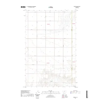
2020 Map of Turner SE
USGS Topo · Published 2020About this map
The boundary between Blaine Co and Phillips Co defines this northern Montana landscape, where a grid of rural roads connects remote agricultural holdings. Drainages such as Little Jewel Coulee and Black Coulee cut through the terrain, providing the primary topographical relief in an area dominated by large-scale land divisions. The road network is marked by family-named routes such as Wolery Rd, Skones Ln, and Tooke Rd, reflecting a lineage of land ownership and settlement in this portion of the state. Other significant transit corridors include Loring Rd and Country Club Rd, which traverse the open range between Little Jewell Rd and Black Coulee Rd. This survey documents the intersection of modern cartography and traditional land management at the start of the 2020s.
Find a feature on this map
18 named features on this map. Tap any name to fly to it.
Don’t see what you’re looking for? This feature index may not catch every label — zoom into the map to look around manually.
Map Details
Editions of this 2020 Turner SE Map
This is the sole edition of this map. No revisions or reprints were ever made.
Other maps of this area

1920 · Avery
USGS Topo · 1:125,000

1953 · Havre
USGS Topo · 1:250,000

1957 · Havre
USGS Topo · 1:250,000

1958 · Havre
USGS Topo · 1:250,000

1984 · Chapman
USGS Topo · 1:24,000

1984 · Emerick Bench
USGS Topo · 1:24,000
1984 · Chapman NW
USGS Topo · 1:24,000

1984 · Turner
USGS Topo · 1:24,000

1984 · Turner NE
USGS Topo · 1:24,000
1984 · Down Reservoir NW
USGS Topo · 1:24,000