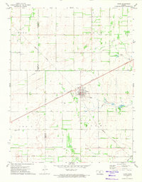
1971 Map of Turon
USGS Topo · Published 1974About this map
Turon serves as the central hub of this South Central Kansas landscape, situated at the critical junction of the Chicago Rock Island and Pacific and the Missouri Pacific railroads. The town's grid is clearly defined, featuring a concentrated residential area and industrial markers like the sewage disposal site. Beyond the town limits, the geography is marked by the historical Old Indian Treaty Boundary, which cuts across the southern portion of the quadrangle near the small settlement of Olcott.
Find a feature on this map
19 named features on this map. Tap any name to fly to it.
Don’t see what you’re looking for? This feature index may not catch every label — zoom into the map to look around manually.
Map Details
Editions of this 1971 Turon Map
This is the sole edition of this map. No revisions or reprints were ever made.
Other maps of this area

1892 · Kingman
USGS Topo · 1:125,000

1892 · Pratt
USGS Topo · 1:125,000

1894 · Kingman
USGS Topo · 1:125,000

1894 · Pratt
USGS Topo · 1:125,000

1955 · Pratt
USGS Topo · 1:250,000

1959 · Pratt
USGS Topo · 1:250,000

1966 · Cunningham
USGS Topo · 1:24,000

1967 · Penalosa
USGS Topo · 1:24,000

1967 · Cairo
USGS Topo · 1:24,000
1971 · Preston
USGS Topo · 1:24,000