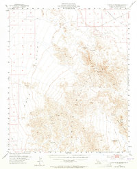
1954 Map of Turtle Mountains
USGS Topo · Published 1965About this map
The Turtle Mountains dominate this mid-century survey of the California desert, flanked by the broad basins of Ward Valley, Chemehuevi Valley, and Vidal Valley. Water sources, critical for survival and exploration in this arid landscape, are carefully documented through labels for Mohawk Spring, Coffin Spring, and Mopah Spring, alongside family-named sites such as Martins Well, Johnsons Well, and Carsons Wells. These points often served as the only hubs of activity for prospectors and travelers moving through the range. Evidence of small-scale mineral exploration is scattered throughout the peaks, indicated by several Prospects, a Shaft, and multiple Tunnels. Notable landmarks like the distinct Mopah Peaks and Castle Rock provide navigational anchors, while a lone Jeep Trail underscores the limited accessibility of the region during the early 1950s.
Find a feature on this map
25 named features on this map. Tap any name to fly to it.
Don’t see what you’re looking for? This feature index may not catch every label — zoom into the map to look around manually.
Map Details
Editions of this 1954 Turtle Mountains Map
3 editions found

Other maps of this area

1903 · Needles
USGS Topo · 1:125,000

1904 · Needles Special
USGS Topo · 1:125,000

1942 · Amboy
USGS Topo · 1:250,000

1943 · Center Hills
USGS Topo · 1:62,500

1943 · Amboy
USGS Topo · 1:250,000

1943 · Essex
USGS Topo · 1:62,500

1943 · Turtle Mts.
USGS Topo · 1:62,500

1943 · Vidal
USGS Topo · 1:62,500

1943 · Iron Mountains
USGS Topo · 1:62,500

1949 · Vidal
USGS Topo · 1:62,500