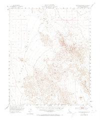
1954 Map of Turtle Mountains
USGS Topo · Published 1974About this map
Turtle Mountains dominate this 1954 survey of the California desert, flanked by the broad reaches of Ward Valley to the west and Chemehuevi Valley to the northeast. Water sources were the vital hubs of movement in this arid landscape, documented here by the presence of Mohawk Spring, Carsons Wells, Coffin Spring, and Martins Well. These features, along with Johnsons Well and Mopah Spring, indicate the historical reliance on isolated water points for transit through the high desert.
Find a feature on this map
27 named features on this map. Tap any name to fly to it.
Don’t see what you’re looking for? This feature index may not catch every label — zoom into the map to look around manually.
Map Details
Editions of this 1954 Turtle Mountains Map
3 editions found

Other maps of this area

1903 · Needles
USGS Topo · 1:125,000

1904 · Needles Special
USGS Topo · 1:125,000

1942 · Amboy
USGS Topo · 1:250,000

1943 · Center Hills
USGS Topo · 1:62,500

1943 · Amboy
USGS Topo · 1:250,000

1943 · Essex
USGS Topo · 1:62,500

1943 · Turtle Mts.
USGS Topo · 1:62,500

1943 · Vidal
USGS Topo · 1:62,500

1943 · Iron Mountains
USGS Topo · 1:62,500

1949 · Vidal
USGS Topo · 1:62,500