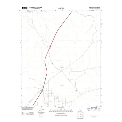
2012 Map of Turtle Valley
USGS Topo · Published 2012About this map
Turtle Valley and the southern slopes of Stoddard Mountain characterize this high desert landscape during the early 21st century. The map reveals a transition between the rugged topography of Turtle Mountain and the expanding residential grid south of Sombre Rd. This development is particularly evident in the cluster of streets like Dachshund Ave and Weimar Ave, which stand in contrast to the historical routes of the Overland Trl and Panamint Trl further north.
Find a feature on this map
40 named features on this map. Tap any name to fly to it.
Don’t see what you’re looking for? This feature index may not catch every label — zoom into the map to look around manually.
Map Details
Editions of this 2012 Turtle Valley Map
This is the sole edition of this map. No revisions or reprints were ever made.
Other maps of this area

1932 · Barstow
USGS Topo · 1:125,000

1934 · Barstow
USGS Topo · 1:125,000

1953 · San Bernardino
USGS Topo · 1:250,000

1956 · San Bernardino
USGS Topo · 1:250,000
1956 · Victorville
USGS Topo · 1:24,000

1956 · Hawes
USGS Topo · 1:62,500

1956 · Barstow
USGS Topo · 1:62,500

1956 · Helendale
USGS Topo · 1:24,000
1956 · Victorville
USGS Topo · 1:62,500

1957 · Apple Valley
USGS Topo · 1:62,500