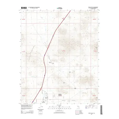
2015 Map of Turtle Valley
USGS Topo · Published 2015About this map
Brisbane Valley and Turtle Valley characterize this arid landscape in the High Desert north of Apple Valley. The terrain is defined by dry drainage systems such as Wild Wash and Bell Mountain Wash, which carve through the Mojave Desert floor between prominent peaks. Significant elevations include Turtle Mtn and Stoddard Mtn, providing landmarks for the rural road network that begins to intensify near the southern boundary. Residential development in the Sidewinder Valley and around Bell Mountain is evidenced by a grid of named streets including Dachshund Ave and Weimar Ave. The presence of Stoddard Wells Rd and Leaping Lizard Ln highlights the transition from open desert to the northern reaches of local community growth.
Find a feature on this map
36 named features on this map. Tap any name to fly to it.
Don’t see what you’re looking for? This feature index may not catch every label — zoom into the map to look around manually.
Map Details
Editions of this 2015 Turtle Valley Map
This is the sole edition of this map. No revisions or reprints were ever made.
Other maps of this area

1932 · Barstow
USGS Topo · 1:125,000

1934 · Barstow
USGS Topo · 1:125,000

1953 · San Bernardino
USGS Topo · 1:250,000

1956 · San Bernardino
USGS Topo · 1:250,000
1956 · Victorville
USGS Topo · 1:24,000

1956 · Hawes
USGS Topo · 1:62,500

1956 · Barstow
USGS Topo · 1:62,500

1956 · Helendale
USGS Topo · 1:24,000
1956 · Victorville
USGS Topo · 1:62,500

1957 · Apple Valley
USGS Topo · 1:62,500