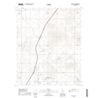
2018 Map of Turtle Valley
USGS Topo · Published 2018About this map
Apple Valley serves as the southern anchor for this desert landscape, where suburban residential grids meet the open expanses of the Mojave Desert. The map reveals a transition from organized street names like Navajo Rd and Dale Evans Prky to the rugged, name-rich peaks of Turtle Mtn and Stoddard Mtn. Historically significant pathways such as the Overland Trl and Panamint Trl cut across the northern reaches, tracing the legacy of desert travel. Between these landmarks, several distinct valleys like Sidewinder Valley and Brisbane Valley are defined by the natural drainage of Wild Wash. This survey captures the encroachment of modern development into the arid interior, evidenced by the expanding network of local roads branching out toward the landmark of Bell Mountain.
Find a feature on this map
60 named features on this map. Tap any name to fly to it.
Don’t see what you’re looking for? This feature index may not catch every label — zoom into the map to look around manually.
Map Details
Editions of this 2018 Turtle Valley Map
This is the sole edition of this map. No revisions or reprints were ever made.
Other maps of this area

1932 · Barstow
USGS Topo · 1:125,000

1934 · Barstow
USGS Topo · 1:125,000

1953 · San Bernardino
USGS Topo · 1:250,000

1956 · San Bernardino
USGS Topo · 1:250,000
1956 · Victorville
USGS Topo · 1:24,000

1956 · Hawes
USGS Topo · 1:62,500

1956 · Barstow
USGS Topo · 1:62,500

1956 · Helendale
USGS Topo · 1:24,000
1956 · Victorville
USGS Topo · 1:62,500

1957 · Apple Valley
USGS Topo · 1:62,500