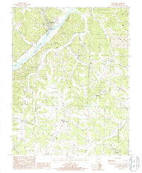
1987 Map of Tuscumbia
USGS Topo · Published 1988About this map
Tuscumbia serves as the focal point of this Miller County landscape, situated along the north bank of a significant bend in the Osage River. The terrain is defined by deep incisions from drainage systems like Cattail Creek and Shutin Creek, creating prominent features such as Cedar Bluffs and Turn Back Ridge. While the river valley provided a natural corridor for early settlement and recreation, evidenced by a Campground and Boat Ramp, the higher elevations served strategic functions in the late 1980s. The Ulman State Tower Site and a nearby Lookout Tower occupied these heights, offering wide views over the township of Equality. Farther south, the small community of Ulman sits at a crossroads, while the landscape transition toward Watkins reveals a network of hollows and ridges like Shoestring Hollow and Prairie Hollow, typical of this region's rugged geography before more modern development altered the rural character.
Find a feature on this map
33 named features on this map. Tap any name to fly to it.
Don’t see what you’re looking for? This feature index may not catch every label — zoom into the map to look around manually.
Map Details
Editions of this 1987 Tuscumbia Map
This is the sole edition of this map. No revisions or reprints were ever made.
Other maps of this area

1888 · Versailles
USGS Topo · 1:125,000

1888 · Tuscumbia
USGS Topo · 1:125,000

1893 · Versailles
USGS Topo · 1:125,000

1894 · Tuscumbia
USGS Topo · 1:125,000

1904 · Eldon
USGS Topo · 1:62,500

1932 · Versailles No 4
USGS Topo · 1:48,000

1933 · Iberia
USGS Topo · 1:62,500

1934 · Toronto
USGS Topo · 1:24,000

1934 · Bagnell
USGS Topo · 1:24,000
1935 · Eldon
USGS Topo · 1:24,000