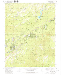
1979 Map of Twain Harte
USGS Topo · Published 1980About this map
Mi-Wuk Village and Twain Harte anchor this survey of the Sierra Nevada foothills during the late 1970s. The landscape is defined by the steep drainage of the South Fork Stanislaus River and the significant industrial footprint of historic mining and timber operations. Subdivisions like Sierra Village and Brentwood Park sit alongside remnants of an earlier economy, including the Confidence Mine, Red Cloud Mine, and the site of Hess Mill. Transportation history is evident in the presence of an Old Railroad Grade and the Italian Bar Road, tracing routes through the Stanislaus National Forest. Water management is prominent throughout the quadrangle, with Lyons Reservoir feeding a network of ditches and flumes that historically supported both hydraulic mining and local development, while Twain Harte Lake serves as a central landmark for the growing mountain community.
Find a feature on this map
58 named features on this map. Tap any name to fly to it.
Don’t see what you’re looking for? This feature index may not catch every label — zoom into the map to look around manually.
Map Details
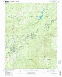
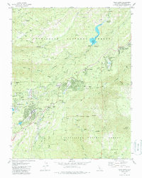
Editions of this 1979 Twain Harte Map
3 editions found
Other maps of this area

1891 · Big Trees
USGS Topo · 1:125,000

1893 · Sonora
USGS Topo · 1:125,000

1894 · Big Trees
USGS Topo · 1:125,000

1896 · Sonora
USGS Topo · 1:125,000

1897 · Sonora
USGS Topo · 1:125,000

1897 · Big Trees
USGS Topo · 1:125,000

1898 · Sonora
USGS Topo · 1:125,000

1901 · Big Trees
USGS Topo · 1:125,000

1947 · Sacramento
USGS Topo · 1:250,000

1947 · San Jose
USGS Topo · 1:250,000