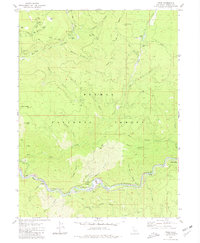
1980 Map of Twain
USGS Topo · Published 1980About this map
Seneca and the remote mining reaches of Plumas National Forest define this 1980 study of the Feather River canyon. The landscape is a complex network of resource extraction and transit, where the Western Pacific railroad tracks parallel the North Fork Feather River and the East Branch North Fork Feather River. Gold mining history is deeply etched into the terrain, evidenced by numerous workings such as the Dutch Hill Mine, Virgilia Mine, and the Swiss Mine.
Find a feature on this map
73 named features on this map. Tap any name to fly to it.
Don’t see what you’re looking for? This feature index may not catch every label — zoom into the map to look around manually.
Map Details
Editions of this 1980 Twain Map
2 editions found
Other maps of this area

1886 · Honey Lake
USGS Topo · 1:250,000

1886 · Lassen Peak
USGS Topo · 1:250,000

1888 · Bidwell Bar
USGS Topo · 1:125,000

1891 · Bidwell Bar
USGS Topo · 1:125,000

1891 · Downieville
USGS Topo · 1:125,000

1891 · Honey Lake
USGS Topo · 1:250,000

1892 · Lassen Peak
USGS Topo · 1:250,000

1893 · Bidwell Bar
USGS Topo · 1:125,000

1893 · Honey Lake
USGS Topo · 1:250,000

1893 · Downieville
USGS Topo · 1:125,000