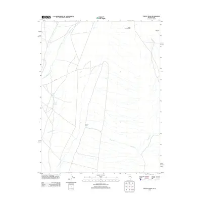
2012 Map of Tweedy Wash
USGS Topo · Published 2012About this map
Needle Point Mountain dominates the northern skyline of this arid landscape on the Nevada-Utah border, where intricate drainage patterns define the valley floor. The hydrology of the region is marked by ephemeral channels like Tweedy Wash and Big Spring Wash, which cut through the high desert toward the southwest. Water sources are scarce but critical, centered around North Little Springs and South Little Springs along the western edge of the quadrangle. These springs and the perennial Big Springs Creek suggest historic points of interest for livestock and early travel through this basin-and-range corridor. The presence of Co RD 44 and other secondary tracks highlights a sparse but functional transit network connecting geographic landmarks such as The Pots and The Cove. This survey provides a baseline of the high-elevation desert terrain before more modern developments or shifts in the local water table.
Find a feature on this map
10 named features on this map. Tap any name to fly to it.
Don’t see what you’re looking for? This feature index may not catch every label — zoom into the map to look around manually.
Map Details
Editions of this 2012 Tweedy Wash Map
This is the sole edition of this map. No revisions or reprints were ever made.
Other maps of this area
1949 · Garrison
USGS Topo · 1:62,500
1951 · Garrison
USGS Topo · 1:62,500

1953 · Richfield
USGS Topo · 1:250,000

1956 · Lund
USGS Topo · 1:250,000

1958 · Richfield
USGS Topo · 1:250,000

1960 · Lund
USGS Topo · 1:250,000
1960 · Burbank Hills
USGS Topo · 1:62,500
1971 · Mountain Home Pass
USGS Topo · 1:24,000
1971 · Mormon Gap
USGS Topo · 1:24,000
1972 · Miller Wash
USGS Topo · 1:24,000