
1960 Map of Burbank Hills
USGS Topo · Published 1962About this map
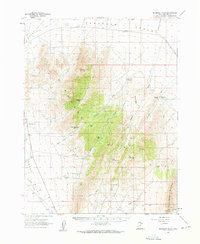
Burbank Hills rise sharply between the Snake Valley to the west and the Ferguson Desert to the east, creating a corridor of high passes and seasonal drainages. During the early 1960s, this arid landscape was defined by its water sources and livestock trails, evidenced by landmarks like Clay Spring, Davies Well, and Hockman Well. The map captures a transition in desert travel, showing the established Garrison Black Rock Road alongside more primitive routes such as the Ferguson Trail and the Cowboy Jeep Trail. In the southern reaches, the Desert Experimental Range occupies a significant portion of the terrain near Tunnel Spring. For those tracking the hydraulic history of the Great Basin, the numerous seasonal catchments like South Cedar Wash Reservoir and Deadman Reservoir provide specific points of reference for mid-century land management and grazing practices.
Find a feature on this map
42 named features on this map. Tap any name to fly to it.
Don’t see what you’re looking for? This feature index may not catch every label — zoom into the map to look around manually.
Map Details
Editions of this 1960 Burbank Hills Map
2 editions found
Other maps of this area

1908 · Fish Springs
USGS Topo · 1:250,000

1910 · Fish Springs
USGS Topo · 1:250,000

1949 · Garrison
USGS Topo · 1:62,500

1951 · Garrison
USGS Topo · 1:62,500

1953 · Richfield
USGS Topo · 1:250,000

1953 · Delta
USGS Topo · 1:250,000

1956 · Lund
USGS Topo · 1:250,000

1956 · Ely
USGS Topo · 1:250,000

1958 · Richfield
USGS Topo · 1:250,000

1958 · Delta
USGS Topo · 1:250,000