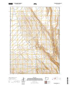
2020 Map of Twelvemile Ridge
USGS Topo · Published 2020About this map
Twelvemile Ridge and the prominent Three Man Butte define the high-desert character of this corner of Malheur County. The map shows a landscape shaped by drainage systems such as Duck Cr and Twelvemile Cr, where seasonal water courses have carved distinct topographical patterns into the terrain. Human presence is marked by a network of ranching and access roads, including Whitehorse Rd and Echave Ranch Rd, which navigate the elevation changes along the Twelvemile Hill Grade. This 2020 survey illustrates the contemporary connectivity of the region through the Whitehorse Cutoff and Crooked Creek Range Rd, providing a clear record of the modern infrastructure serving these remote high-elevation plains.
Find a feature on this map
14 named features on this map. Tap any name to fly to it.
Don’t see what you’re looking for? This feature index may not catch every label — zoom into the map to look around manually.
Map Details
Editions of this 2020 Twelvemile Ridge Map
This is the sole edition of this map. No revisions or reprints were ever made.
Other maps of this area

1955 · Jordan Valley
USGS Topo · 1:250,000

1955 · Adel
USGS Topo · 1:250,000

1957 · Adel
USGS Topo · 1:250,000

1957 · Jordan Valley
USGS Topo · 1:250,000

1958 · Adel
USGS Topo · 1:250,000

1958 · Jordan Valley
USGS Topo · 1:250,000

1962 · Adel
USGS Topo · 1:250,000

1980 · Rome State Airport
USGS Topo · 1:24,000

1981 · Coyote Lake West
USGS Topo · 1:24,000
1981 · Coyote Lake East
USGS Topo · 1:24,000