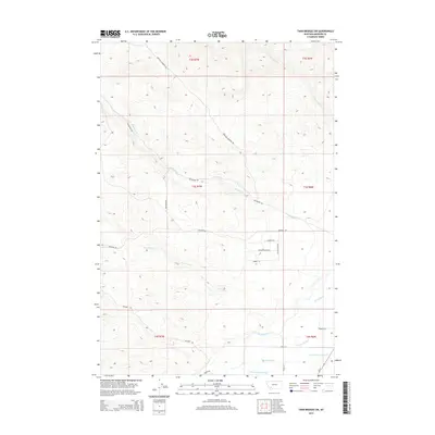
2014 Map of Twin Bridges SW
USGS Topo · Published 2014About this map
Big Hole River winds through the southern reaches of this landscape, its path defined by a complex network of wetlands and side channels including Owsley Slough, Third Slough, and Schoolhouse Slough. The terrain transitions from these low-lying watercourses in the south to rising slopes in the north, drained by Rochester Cr, Nez Perce Cr, and Cottonwood Cr. Human activity is primarily traced through a grid of established routes such as Highland Ironrod Rd and Rochester Rd, alongside more localized paths like McCarty Rd and Melrose Rd. These roads suggest a ranching or agricultural pattern, connecting remote parcels within the township and range boundaries of t3s r7w and t4s r6w. The presence of Walking Horse Ln and Valley View Dr indicates modern residential pockets emerging among the older drainage-oriented land use.
Find a feature on this map
26 named features on this map. Tap any name to fly to it.
Don’t see what you’re looking for? This feature index may not catch every label — zoom into the map to look around manually.
Map Details
Editions of this 2014 Twin Bridges SW Map
This is the sole edition of this map. No revisions or reprints were ever made.
Other maps of this area
1893 · Dillon
USGS Topo · 1:250,000

1955 · Dillon
USGS Topo · 1:250,000

1957 · Dillon
USGS Topo · 1:250,000

1958 · Dillon
USGS Topo · 1:250,000
1960 · Block Mountain
USGS Topo · 1:24,000
1960 · Twin Bridges
USGS Topo · 1:62,500
1961 · Wickiup Creek
USGS Topo · 1:24,000
1961 · Nez Perce Hollow
USGS Topo · 1:24,000

1962 · Dillon
USGS Topo · 1:250,000
1962 · Beaverhead Rock
USGS Topo · 1:24,000