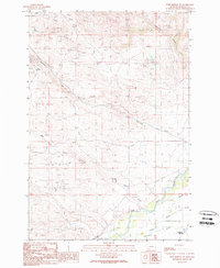
1989 Map of Twin Bridges SW
USGS Topo · Published 1989About this map
Mining and ranching geography define this Madison County landscape as it appeared in the late 1980s. High-elevation extraction sites like the Elgin Mine and Eclipse Mine are situated among a dense network of prospects and shafts, illustrating the region's enduring mineral interest. To the south, the topography descends into the complex riparian environment of the Big Hole River, where the Third Slough and Owlsley Slough create a braided waterway system essential for local irrigation.
Find a feature on this map
14 named features on this map. Tap any name to fly to it.
Don’t see what you’re looking for? This feature index may not catch every label — zoom into the map to look around manually.
Map Details
Editions of this 1989 Twin Bridges SW Map
This is the sole edition of this map. No revisions or reprints were ever made.
Other maps of this area

1893 · Dillon
USGS Topo · 1:250,000

1955 · Dillon
USGS Topo · 1:250,000

1957 · Dillon
USGS Topo · 1:250,000

1958 · Dillon
USGS Topo · 1:250,000

1960 · Block Mountain
USGS Topo · 1:24,000

1960 · Twin Bridges
USGS Topo · 1:62,500

1961 · Wickiup Creek
USGS Topo · 1:24,000

1961 · Nez Perce Hollow
USGS Topo · 1:24,000

1962 · Dillon
USGS Topo · 1:250,000
1962 · Beaverhead Rock
USGS Topo · 1:24,000