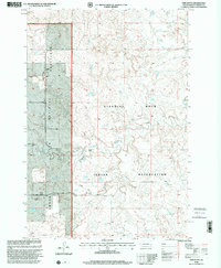
1998 Map of Twin Butte
USGS Topo · Published 2001About this map
The Standing Rock Indian Reservation and Grand River National Grassland meet along a distinct boundary line in this northern South Dakota landscape. Settled life in the late 20th century is defined by isolated family operations such as the G Miller Ranch, B Rieger Ranch, and Shambo Ranch. The Grand River flows through the southern portion of the quadrangle, joined by tributaries like Horse Butte Creek and Twin Butte Creek. A lone Cem and the Black Horse Arena serve as important local markers for genealogical and community history. The land is largely open, with a small Landing Strip providing essential aerial access to this expansive prairie region. Notable topographical prominence is found at Twin Butte, standing as a landmark over the surrounding river valley and ranch lands.
Find a feature on this map
14 named features on this map. Tap any name to fly to it.
Don’t see what you’re looking for? This feature index may not catch every label — zoom into the map to look around manually.
Map Details
Editions of this 1998 Twin Butte Map
This is the sole edition of this map. No revisions or reprints were ever made.
Other maps of this area

1953 · McIntosh
USGS Topo · 1:250,000

1956 · Cottonwood Creek NW
USGS Topo · 1:24,000

1956 · Cottonwood Creek SW
USGS Topo · 1:24,000

1958 · McIntosh
USGS Topo · 1:250,000

1972 · Black Horse Butte NW
USGS Topo · 1:24,000

1972 · Black Horse Butte
USGS Topo · 1:24,000

1972 · Twin Butte
USGS Topo · 1:24,000

1972 · Black Horse Butte NE
USGS Topo · 1:24,000

1980 · McIntosh
USGS Topo · 1:100,000

1982 · Glad Valley
USGS Topo · 1:24,000