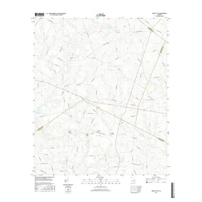
2017 Map of Twin City SE
USGS Topo · Published 2017About this map
Fifteenmile Creek and Cypress Creek define the low-lying drainage patterns of this rural Georgia landscape where Bulloch, Emanuel, Jenkins, and Candler counties meet. The map reveals a persistent network of family-named roads and remote crossings that speak to the area's agricultural and social foundations. Key landmarks include several vital transit points such as Paddy Ford Bridge, Emmit Brown Bridge, and Banks Bridge, which span the winding waterways. For genealogists, the map provides precise locations for several local burial sites, including Bethel Cemetery, El Bethel Cemetery, and Friendship Cemetery. The presence of Watson Pond, Bowen Lake, and Donaldson Lake indicates a landscape heavily influenced by both natural wetlands and managed water resources, tied together by long-established routes like Old Garfield Road and Friendship Church Road.
Find a feature on this map
83 named features on this map. Tap any name to fly to it.
Don’t see what you’re looking for? This feature index may not catch every label — zoom into the map to look around manually.
Map Details
Editions of this 2017 Twin City SE Map
This is the sole edition of this map. No revisions or reprints were ever made.
Other maps of this area
1920 · Statesboro
USGS Topo · 1:62,500
1921 · Rocky Ford
USGS Topo · 1:62,500
1943 · Rocky Ford
USGS Topo · 1:62,500
1943 · Millen
USGS Topo · 1:125,000
1943 · Statesboro
USGS Topo · 1:62,500
1947 · Savannah
USGS Topo · 1:250,000
1948 · Savannah
USGS Topo · 1:250,000
1957 · Macon
USGS Topo · 1:250,000
1957 · Savannah
USGS Topo · 1:250,000
1958 · Macon
USGS Topo · 1:250,000